
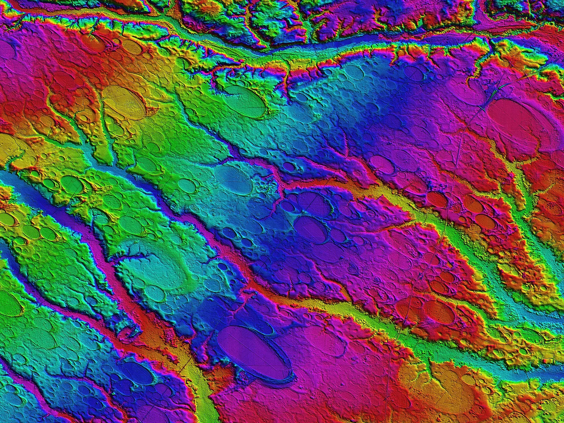
From the ground they are easy to miss: a swamp thick with bay trees, a shallow lake ringed by cypress, a field that stays wet after rain. From the air, or on a modern elevation map, they jump out. Across the Atlantic coastal plain, and above all in the Carolinas, thousands of smooth oval hollows lie scattered over the landscape, many overlapping one another, almost all pointing the same way, from northwest to southeast, and many trimmed on their southeastern ends with a low rim of pale sand. They are the Carolina bays, and how they formed is one of the longest-running arguments in American geology.
What happened
The North Carolina encyclopedia NCpedia counts fewer than 900 notable bays today, about four in five of them in North Carolina, with the densest cluster in Bladen County, though earlier estimates ran into the hundreds of thousands and the features reach north into Maryland and south into Georgia and Florida. They range from a few hundred feet to roughly six miles long. Some still hold open water, including Lake Waccamaw, White Lake and Bay Tree Lake; others have filled with peat up to fifty feet deep or been drained for farms and timber. The geologist L. C. Glenn first drew attention to the shared shape of these “bays” in 1895.
The puzzle became famous in the 1930s, when aerial photography revealed how regular the pattern was. In 1933 Frank Melton and William Schriever proposed that the bays were scars left by a swarm of meteorites striking the coastal plain at a low angle from the northwest, which would explain both the ellipses and the shared alignment. For decades the meteorite idea was the popular explanation.
The investigation
Searches for the physical traces of an impact came up empty. The South Carolina Encyclopedia lists the problems: no gravity or magnetic anomalies beneath the bays, no shocked quartz in the surrounding sand, and shapes that are elliptical when impact craters are almost always round. The bays also stop at the edge of the coastal plain. A random shower from space should have pocked the hard rock of the Piedmont too, but the bays only form in loose, sandy sediment.
The decisive evidence came from dating the sand rims. Optically stimulated luminescence, a method that measures how long ago grains of sand were last exposed to sunlight, has been applied to bay rims in South Carolina and Georgia by Andrew Ivester, Mark Brooks and colleagues. At Flamingo Bay near the Savannah River, one rim was active about 109,000 years ago and again around 40,000 years ago. Across many bays, some 45 dates cluster in several cold periods over the last 130,000 years, and where a bay has several concentric rims, the inner ones are younger. That is the pattern of a lake shrinking and reshaping its shore over long stretches of time, not of a hole punched in a single instant.
The explanations
The view now favored by most geologists is that the bays began as shallow ponds on the flat, sandy plain and were molded by wind. Steady winds blowing across the water during colder, drier phases of the Ice Age drove waves and currents that eroded the basins into ovals and swept sand onto their downwind shores, building the rims. Other proposals involve groundwater dissolving the sediment beneath, or tidal eddies along an old shoreline; none has displaced the wind-and-water model, and the South Carolina Encyclopedia still says a definitive explanation has yet to emerge.
The impact idea did not disappear. In the 2000s a group of researchers including Richard Firestone and Allen West proposed that a comet broke up over North America about 12,900 years ago, triggering the cold snap known as the Younger Dryas. In one paper they reported a thin layer of magnetic grains, tiny spherules and glassy carbon in the rims of 16 Carolina bays and suggested an impact near the Great Lakes. Measurements published in 1942 had already shown that the long axes of the southern bays, extended inland, converge on southeastern Indiana and southwestern Ohio. The problem for the comet version is the clock: luminescence dates put many rims tens of thousands of years older than 12,900 years, so even where a layer of that age turns up in a rim, the event that deposited it did not create the bay.
Where it stands
The shapes are not in doubt, and LiDAR elevation maps now show them in extraordinary detail. The weight of the dating evidence points to slow formation by wind and water across many glacial cycles, with no sign of a single cosmic strike. The finer mechanics are still being worked out, and the bays remain a draw for anyone who prefers a catastrophe. Several are protected, including Woods Bay State Park in South Carolina.