
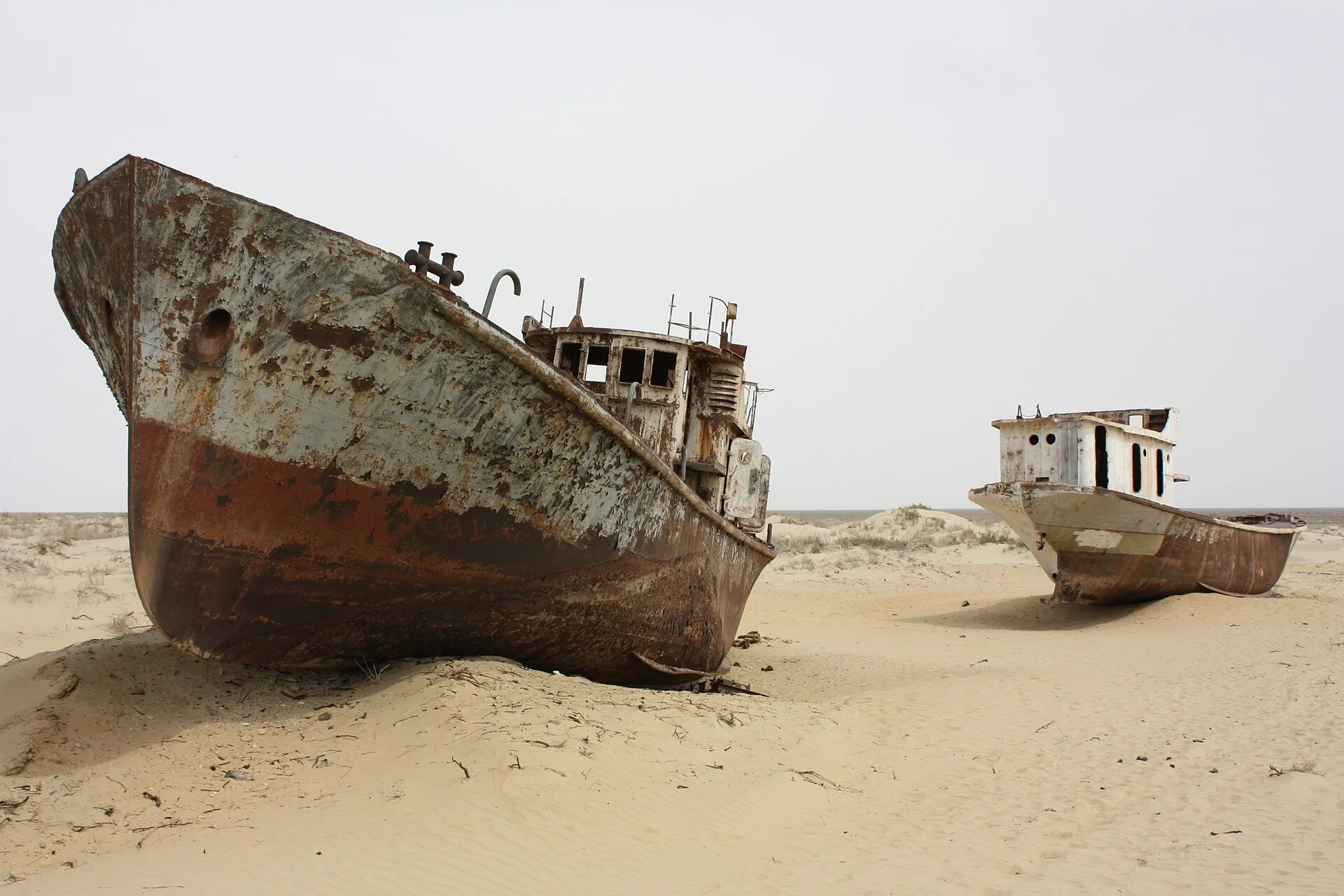
Moynaq, also written Muynak or Mo’ynoq, lies in the far northwest of Uzbekistan in the autonomous republic of Karakalpakstan. Until the 1980s it was a port. The Aral Sea, fed by the Amu Darya from the south and the Syr Darya from the north, covered about 67,500 square kilometers, twice the area of Belgium, and was the fourth-largest lake on earth. Moynaq sat on a peninsula on its southern shore, with a harbor, a fishing fleet and a cannery, and the sea supplied roughly one-sixth of all the fish eaten in the Soviet Union.
What happened
In the 1960s Soviet planners set out to make Central Asia the world’s largest cotton producer. Irrigation canals drew off most of the flow of both rivers before it reached the sea, and the sea, which has no outlet and survives only on inflow, began to shrink. Satellite imagery compiled by NASA shows the outline of 1960 against what followed: the lake split in two, the southern half split again, and the shoreline fell back by tens of kilometers. As the volume dropped the water grew saltier and the pesticides and fertilizer washed in from the fields grew more concentrated, until the fish died. A fisherman on the Kazakh shore told the BBC that his last net, in 1976, came up full of dead fish.
Moynaq’s harbor emptied in the same years. The bigger trawlers could not reach the receding dock and one by one grounded in the soft mud, where they stayed. On the Kazakh shore, crews were sent nearly 2,000 kilometers away to fish Lake Balkhash for half of every year. Moynaq’s cannery, which had sent 22 million tins of pike, perch and other fish across the USSR annually, closed in 1991, the year the Soviet Union itself ended. A former furnace worker who spent 30 years there later showed a visiting writer the empty sheds. The population, which had been in the tens of thousands, fell to around 13,000.
The investigation
There was never anything hidden about the Aral’s decline, only something unsaid. The sea’s shrinking was visible from orbit, and NASA’s Earth Observatory has published a year-by-year sequence from 2000 that shows the eastern basin of the southern sea vanishing altogether in 2014. What the Uzbek authorities did not publicize was when the Amu Darya stopped reaching the sea at all, which happened some time in the early 2010s. The consequences on land have been measured since: the exposed seabed, now called the Aralkum, throws up salt and dust laced with agricultural chemicals; the summers are hotter and the winters colder without a large body of water to moderate them; and in May 2018 a three-day storm carried salt across Karakalpakstan, Khorezm and into northern Turkmenistan, whitening fields, grounding flights at Urgench and sending people to hospital with breathing problems.
The explanations
Moynaq is a ghost town in the honest sense: not abandoned, but outlived by the thing that made it. The cause is not disputed by anyone. It is the clearest case on record of a large body of water removed by irrigation policy, decided in Moscow and carried out in the name of cotton, a crop that still accounts for a large share of Uzbekistan’s exports. The one qualification is that the story is not entirely over. In 2005 Kazakhstan completed the Kok-Aral dam across the strait between the northern and southern basins, keeping the Syr Darya’s water in the small northern sea; its level rose within a year and fishing there has resumed, with flounder, perch and carp back in the nets. The southern basin that Moynaq once stood on receives no such relief, and the nearest open water is now a drive of three or four hours across the old seabed to the foot of the Ustyurt plateau.
Where it stands
The ship graveyard lies below the old lighthouse at the north end of town: a dozen rusting hulls, covered in chalk graffiti, with a memorial and an information board. A one-room museum in the center displays photographs of the harbor in its working years, tins from the cannery and paintings of the sea. Visitors come on day trips from Nukus and Khiva, and from 2018 an electronic music festival called Stihia, Russian for the elemental force of nature, drew thousands to the seabed before moving elsewhere after the pandemic. The town survives on tourism, gas extraction in the desert and the small lakes and reed beds that remain, and on the memory, still vivid for its older residents, of waves breaking where the sand now blows.