
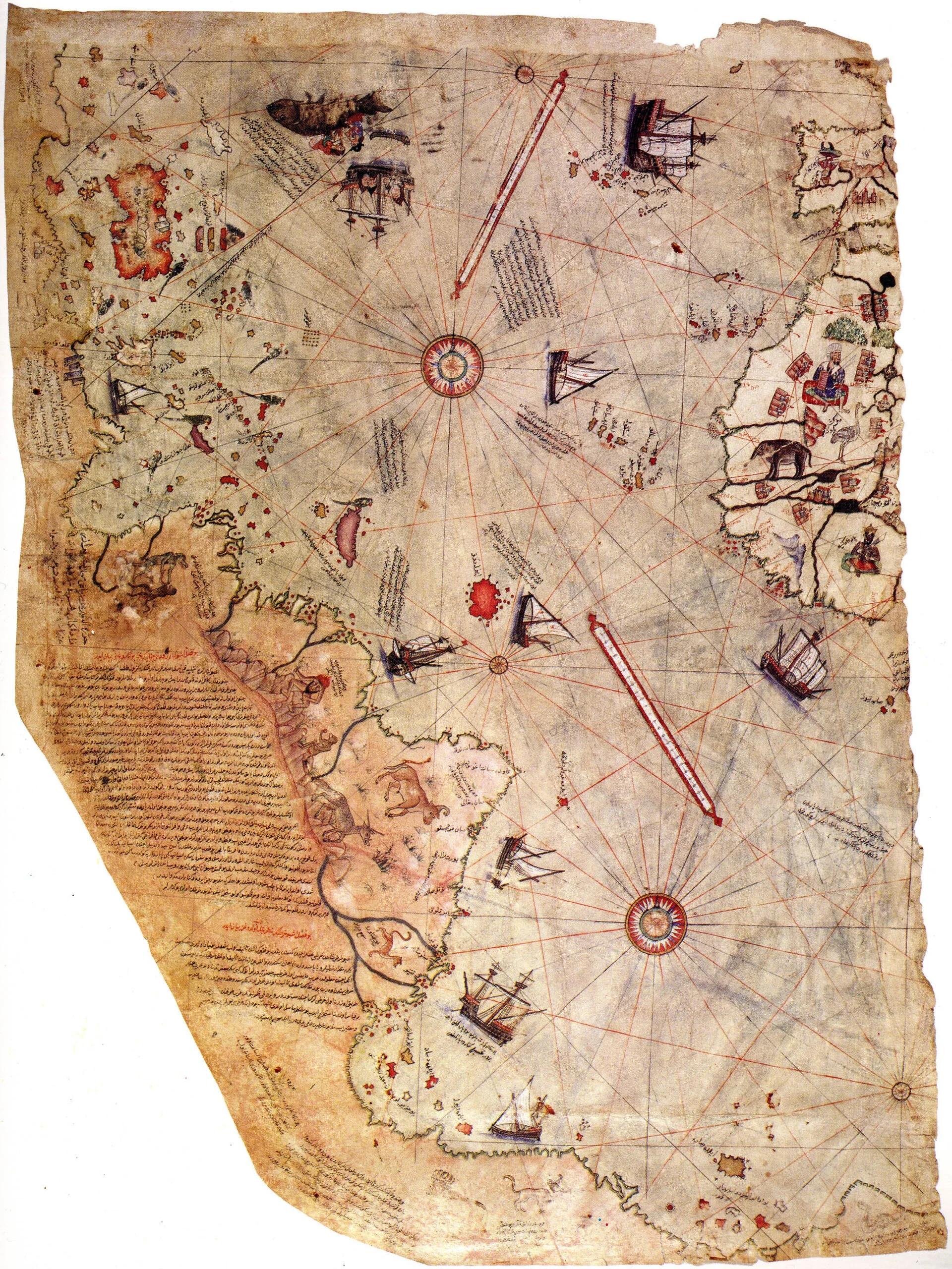
The Piri Reis map is a real and important object: one of the earliest surviving maps to show the New World, signed by an Ottoman sea captain at Gallipoli in 1513, only twenty-one years after Columbus first reached the Caribbean. Since the 1960s it has also been one of the most cited pieces of evidence for a lost advanced civilization, on the strength of a claim that its lower edge shows the coast of Antarctica as it looked before the ice.
What the map is
Piri Reis, born Muhiddin Piri, learned the sea under his uncle Kemal Reis, a corsair turned Ottoman admiral. His map was a world chart drawn in color on animal-skin parchment, and only its western part survives: the Atlantic, with Spain and West Africa on the right, the Caribbean and the coast of Brazil on the left, compass roses and wind lines across the ocean, and illustrations of ships, monsters and local rulers. Notes written on the map say Piri compiled it from about twenty older charts, including Ptolemaic world maps, an Arab map of India, Portuguese charts, and a map of the western lands drawn by Columbus. By the usual account the Columbus chart came from a Spanish sailor captured by Kemal Reis around 1501. After the Ottoman conquest of Egypt in 1517, Piri presented the finished work to Sultan Selim I, rose to admiral, and wrote a celebrated sailing guide to the Mediterranean.
The fragment then disappeared into the library of the Topkapı Palace in Istanbul. It was found in 1929, when the palace was being converted into a museum, and the German orientalist Paul Kahle announced it to scholars in 1931. The excitement was over Columbus. His own charts are lost, and the map seemed to preserve one at secondhand.
How Antarctica entered the story
In the 1950s Arlington Mallery, an engineer with theories about pre-Columbian voyages, argued that early maps hid accurate coastlines that could be recovered by redrawing their grids. Charles Hapgood, a history teacher at Keene State College in New Hampshire, took up the idea with his students and published the results in 1966 as Maps of the Ancient Sea Kings. Hapgood read the land running east along the bottom of the Piri Reis map as Queen Maud Land in Antarctica, free of ice, and proposed that the map descended from charts made thousands of years ago by a seafaring civilization unknown to archaeology. He printed a 1960 letter from Lieutenant Colonel Harold Ohlmeyer of a US Air Force reconnaissance squadron agreeing that the coastline matched seismic profiles of the bedrock beneath the ice. Erich von Däniken repeated the claim in Chariots of the Gods, crediting the information to visitors from space, and later writers including Graham Hancock have kept it in circulation.
The cartographic reading
Historians of cartography do not accept the Antarctic identification, and the reasons are mostly on the map itself. The southern land is joined to Brazil with no sea passage between them, and a note written on it says the country is desolate and hot, with big snakes, which is why the Portuguese did not land there. That describes a tropical shore, not a polar one. Maps of the period routinely drew an imagined southern continent, Ptolemy’s unknown land, below the known world, and coastlines were often turned to fit the shape of the skin they were drawn on. The simplest reading is that Piri continued the South American coast eastward along the bottom of his parchment, adding land he had heard about or assumed.
Hapgood’s case for accuracy also depended on his method. As the geologist Paul Heinrich has pointed out, Hapgood assumed that the map was assembled from precise lost originals, then shifted, rotated and rescaled sections until they fit modern outlines, which removes the errors by design. The Ohlmeyer comparison rested on one seismic line across a vast area, and it treated the bedrock under today’s ice as if it were the coastline of an ice-free continent, ignoring the way land rebounds and sea level rises when ice sheets melt. Antarctica has in any case been ice-covered for millions of years, long before any human could have mapped it. In 2000 the historian Gregory McIntosh published the most detailed modern study of the map, translating all its inscriptions and place-names; he traced the Caribbean section to Columbus’s second voyage and rejected both the lost-civilization and the extraterrestrial readings.
Where it stands
The fragment remains in the Topkapı Palace Museum collection. As a document of how news of the Americas reached Istanbul, it is genuine and remarkable. As proof that someone charted an ice-free Antarctica, it does not hold up.